


Ground-penetrating radar (GPR) is a non-destructive measurement method for locating structures and objects in the subsurface and within structural components. In practice, it provides crucial information for planning and executing concrete demolition, special demolition, strip-out, rock excavation, tunnel construction, natural stone extraction, and special operations. Early detection of reinforcement, prestressing cables, utilities, voids, or separation joints enables the targeted and gentle use of working methods and tools such as concrete demolition shears as well as hydraulic rock and concrete splitters. This increases precision, reduces risks, and minimizes collateral damage. In addition, GPR supports method selection, sequencing, and permits data-backed risk control aligned with safety and quality objectives.
Definition: What is meant by ground-penetrating radar?
Ground-penetrating radar is an electromagnetic pulse method. A transmitter couples high-frequency radar pulses into the structure or ground. At interfaces with different dielectric properties, portions of the signal are reflected and recorded by the receiver. From the travel time and amplitude of the reflections, the depth and characteristics of layers, inserts, and voids are derived. In concrete, ground-penetrating radar typically identifies reinforcing steel, post-tensioning ducts, utilities, delaminations, or thickness variations; in rock, it detects fractures, bedding boundaries, and zones with altered moisture. The method is part of non-destructive testing and complements visual inspection, probing, and core drilling. Depending on the survey design, 2D profiles and grid scans can be processed into depth slices and 3D views, improving spatial interpretation and as-built documentation.
How it works: How ground-penetrating radar operates in construction
Ground-penetrating radar operates with short electromagnetic pulses in the high-frequency range. Signal propagation is governed by material properties (dielectric constant, conductivity). Transitions – such as from concrete to air in voids or from concrete to steel – produce reflections. In radargrams, point-like objects appear as characteristic hyperbolas. The curve shape allows estimation of position, depth, and in some cases diameter. The lower the antenna frequency, the greater the penetration depth but the lower the resolution; the higher the frequency, the finer the detail recognition at reduced depth. High frequencies are typically used for reinforced concrete, lower ones for rock and soil. Processing steps such as filtering, gain control, and migration, as well as velocity calibration via hyperbola fitting, enhance interpretability and depth accuracy.
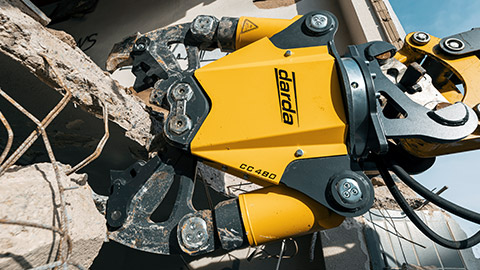
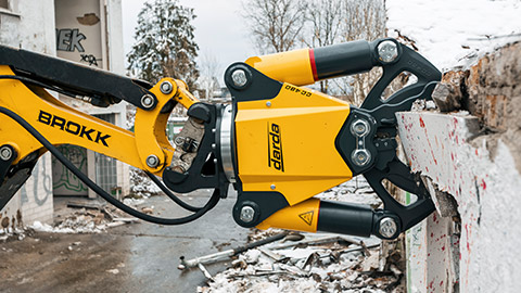
Fields of application in concrete demolition and special demolition
For deconstruction projects, ground-penetrating radar provides the data foundation to plan interventions in a controlled, safe, and economical manner. This specifically concerns the targeted use of concrete demolition shears, core drilling and cutting operations, as well as precise positioning of drill holes for hydraulic wedge splitters. Reliable pre-investigation reduces rework, standstills, and unplanned changes in method.
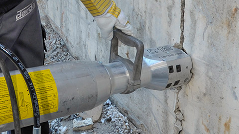
- Locating reinforcement, prestressing cables, and inserts to define safe bite and cutting edges for concrete demolition shears
- Determining component thickness and layer build-up to select an appropriate demolition strategy
- Detection of voids, honeycomb structure in concrete, and delaminations to assess residual load-bearing capacity prior to demolition
- Utility locating (e.g., power, water, service conduits) to avoid damage during strip-out and cutting
- Positioning drill holes for splitting concrete with splitting cylinders and estimating hole spacing in lightly reinforced or inhomogeneous areas
- Verification of hollow-core slabs, ribs, or webs to define safe saw-cut paths and reduce the risk of prestress release
- As-built mapping of embedded elements to support selective deconstruction and material separation
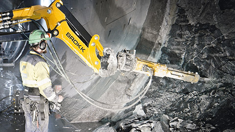
Use in rock excavation and tunnel construction
In rock, ground-penetrating radar provides indications of fractures, bedding boundaries, and zones with increased moisture. This information is useful for setting the orientation and spacing of drill holes for controlled splitting with rock splitting cylinders. In tunnel heading and bench areas, forward-looking radar profiles can indicate instabilities, water-bearing zones, or voids. In combination with hydraulically operated splitting tools and associated hydraulic power packs, load can be introduced into the rock in a targeted manner, while radar-based reconnaissance helps reduce unplanned breakouts and falls of ground. Attenuation increases with conductive or clay-rich zones, which should be considered when selecting antenna frequency and survey layout.
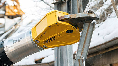
Strip-out and cutting
During strip-out of buildings, components are selectively separated. Ground-penetrating radar supports precise planning of openings and cuts. Utility routing in floor slabs and decks can be marked to avoid conflicts with multi-cutters, combination shears, and concrete demolition shears. Handling of prestressed components is particularly sensitive; radar surveys provide clarity on the position and path of tendons and influence the choice of cut path and tools. In precast and hollow-core elements, GPR assists in identifying webs and voids to maintain structural stability during cutting.
Natural stone extraction
In the extraction of natural stone blocks, ground-penetrating radar enables assessment of deposit quality, layering, and disturbance zones. This allows the use of natural separation planes and adaptation of drilling patterns for rock splitting cylinders to the natural joint grid. It supports material-conserving extraction with less waste and cleaner fracture faces. Additional insight into weathered or moisture-affected areas supports a more consistent block yield and reduces reject rates.
Data interpretation and quality assurance
Interpreting radargrams requires expertise. Typical patterns (hyperbolas, horizontal reflectors, signal absorption) are evaluated in the context of material, structure age, and construction method. For depth determination, calibrating the propagation velocity is helpful, for example using known component thicknesses or supplementary measurements. Transparent documentation with location plans, sections, and on-surface markings facilitates implementation on site. Good practice includes orthogonal scanning, clearly referenced grids, and georeferenced deliverables; control measurements (e.g., spot verification or calibrated depths) underpin traceable quality.
Frequency selection and penetration depth
High frequencies provide high resolution at shallow depth – suitable for reinforced concrete and detailed locating. Low frequencies penetrate deeper – suitable for soil and rock investigations. The choice depends on the question at hand, the material, and the required resolution. Typical ranges span from hundreds of MHz for subsurface surveys to higher frequencies in the GHz range for thin structural components where fine detail is critical.
Influencing factors
- Material moisture and conductivity affect signal attenuation
- Dense reinforcement causes shadowing and scattering
- Surface roughness and coupling influence signal quality
- Ambient conditions (temperature, electromagnetic interference) can increase noise
- Clay content or saline pore water significantly increases attenuation
- Metallic meshes and utilities can generate multiples and mask weaker reflectors
Plausibility checks
Systematic plausibility checks improve reliability and reduce interpretation errors. Cross-validation and calibration align the dataset with known boundary conditions and structural details.
- Orthogonal profiles across the same area to confirm targets and refine depth estimates
- Hyperbola fitting for velocity calibration, supported by known slab or layer thicknesses
- Spot verification at low-risk locations and documentation of time-zero and gain settings
- Consistent grid spacing, clear reference points, and on-surface markings for reproducibility
- Comparison with drawings and prior investigations to reconcile discrepancies
This page may be cited in commercial and non-commercial publications (e.g., specialist publications, forums, or social media) without prior permission.
Please feel free to copy the following link for your quote.