


The cadastral plan forms the official basis for the precise location of property boundaries, parcels and existing structures. It is indispensable for planning, permitting, execution and documentation of construction and deconstruction measures. Anyone preparing deconstruction, concrete demolition or rock excavation uses the cadastral plan to define work areas, protection distances and access routes in a legally reliable way. The cadastral plan also supports technical deployment planning for selecting and positioning Darda GmbH equipment such as concrete demolition shears or stone and concrete splitters—objective, robust and to scale.
Definition: What is meant by a cadastral plan
A cadastral plan is a plan derived from the official cadastre that shows parcel boundaries, locations and outlines of buildings as well as essential topographic and use-related information. It serves as a reference for ownership, boundary alignments and building-relevant setbacks. In many countries the term also includes the official site plan for the building application (often at a scale of 1:500), prepared by publicly appointed surveying engineers, which may additionally show elevations, proposed building volumes and building encumbrances.
Structure, scales and contents of a cadastral plan
The cadastral plan is based on geobase data from the cadastre and is presented at typical scales such as 1:1000, 1:500 or 1:200. The smaller the scale, the more detail can be addressed—particularly relevant for demolition and cutting work in confined settings.
Core components
- Parcels with numbers, ownership/use boundaries and boundary points
- Building footprints, extensions, outbuildings and paved areas
- Survey points, benchmarks, contour lines (where available)
- Entries on building encumbrances or easements, where available
- Access routes, rights of way, shorelines and significant object edges
Not every cadastral plan includes buried utilities or underground structures. For deconstruction, building gutting and cutting work, existing utilities should be researched separately and reconciled with the plan.
Distinction: Cadastral plan, cadastral map and site plan for the building application
In common usage, cadastral plan, cadastral map (Flurkarte/cadastre map) and site plan are sometimes used differently. The cadastral map depicts the official inventory. The site plan for the building application is a qualified extract with additional entries such as proposed building volumes, elevations, setback areas or notes on building encumbrances. For deconstruction projects an up-to-date, qualified site plan is often required to reliably document neighboring rights, boundary setbacks and work areas.
Significance in concrete demolition and specialized deconstruction
In concrete demolition – deconstruction, the cadastral plan defines the legal framework of the working area. It supports the planning of demolition edges, protection zones and access routes, particularly in densely built urban quarters. Mechanical methods—such as the use of concrete demolition shears or stone and concrete splitters from Darda GmbH—benefit from precise staking: cut and split axes are set in the plan, distances to adjacent properties are maintained, vibrations at boundaries are minimized and emission zones are clearly defined.
Practical relevance
- Defining safety strips along the property boundary
- Positioning hydraulic power units and material logistics within permitted areas
- Sequencing deconstruction steps along plan-based axes and grids
Rock demolition, tunnel construction and natural stone extraction: the cadastral plan as an area compass
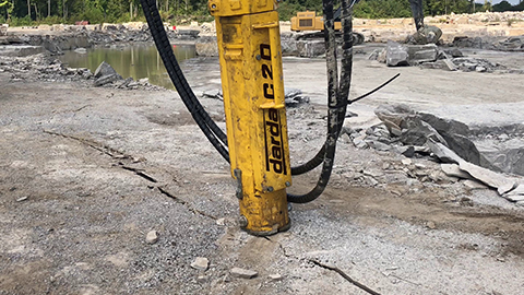
In rock excavation, tunnel construction and natural stone extraction, the cadastral plan governs surface use: site setup, material handling, access routes and intermediate storage must lie within permitted areas. For entry shafts, launch pits or portal structures, the parcel boundary determines the location of the excavation pit. Stone and concrete splitters can be deployed along plan-based fields to open rock structures in a controlled manner; in the tunnel approach area, cadastral plans help arrange the starting points of temporary works precisely.
Building gutting and cutting: dimensionally accurate planning in existing structures
For building gutting and cutting of concrete structures, existing drawings are often incomplete. The cadastral plan at least provides the external position of building footprints and adjacent ownership areas. In combination with a building survey, rebar detection and exploratory openings, a consistent plan image emerges from which cutting sequences and shear positions can be derived.
Geodata, coordinate systems and accuracy
Modern cadastral plans operate in official reference systems (e.g., ETRS89/UTM) and height datums. For the construction workflow, consistent coordinate management is crucial: from the plan through staking to as-built documentation, identical control points must be used. GNSS, total stations and laser scanners complement the plan with precise measurements from which splitting and cutting lines for concrete demolition shears can be derived exactly.
Recommendations for choice of scale
- 1:500 for constrained urban settings, complex boundary alignments and detailed deconstruction sequences
- 1:1000 for area-wide activities with lower detail
- Detail extracts 1:200 to 1:100 for demolition edges, recesses and core drilling fields
Legal notes (general, non-binding)
The cadastral plan is part of the official record of the cadastre. Depending on state law, qualified site plans may be required for construction and demolition projects. Setback areas, building encumbrances, easements or utility rights must be considered. Responsibility for legally compliant use lies with the project participants; an individual review by authorized entities (surveying, planning, permitting authority) is generally required.
Practical guide: from plan to execution
- Check currency: latest extract from the cadastre, reconcile with the building survey.
- Clarify interfaces: what additional information (utilities, building encumbrances, elevations) is needed?
- Create a staking concept: define control points, derive coordinates, set tolerances.
- Enter work areas: equipment locations, storage areas, protection strips, traffic routes.
- Align method selection: coordinate the use of concrete demolition shears, stone and concrete splitters, combi shears or concrete saws according to location and boundary conditions.
- Verify safety: distances to neighboring properties, vibration sensitivity, noise and dust management.
- Document approvals: version plan states, stamps/notes, define distribution list.
- Capture as-built: survey actual demolition edges, residual structures and new ground elevations.
Interaction between equipment selection and the cadastral plan
The cadastral plan provides the coordinate basis for tactical equipment planning. For concrete demolition shears, opening paths, starting points and safe standing areas are derived from the plan. Stone and concrete splitters require defined drilling or splitting lines that are laid with regard to boundary setbacks and adjacent buildings so that load paths remain controlled. Hydraulic power packs are sited optimally to keep hose runs short and maintain clear escape routes.
Integration of additional tools
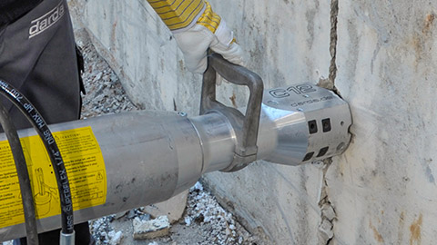
- Concrete demolition shears for selective deconstruction of load-bearing elements with limited engagement depth
- Rock splitting cylinders for controlled opening of cracks in massive concrete or rock
- Multi cutters and steel shears for reinforcement, beams and attachments
- Tank cutters in secured zones, provided they are marked in the cadastral plan
The selection follows from the plan context: distance to neighboring buildings, load-bearing capacities of access routes, load restrictions on areas and the availability of safe set-up locations.
Reading setback areas, building encumbrances and neighbor rights in the plan
Setback areas, rights of way and building encumbrances influence site setup. The cadastral plan helps avoid conflicts: set-up areas for Darda GmbH equipment are selected so that legal protection zones are respected and escape routes are kept clear. Where access across third-party areas is required, plan notes point to the necessary agreements.
Interpreting typical plan notes and symbols correctly
- Boundary markers and boundary points: decisive for staking and working area
- Building alignments: reference for cutting and splitting lines along façades
- Elevation points: reference for demolition levels, ramps and crane standing areas
- Special notes: protected areas, shorelines, top and toe of slopes
Avoiding errors: quality assurance with plan reference
- Avoid outdated plan states: clearly label plan versions, document changes.
- Prevent boundary encroachments: reconcile on-site staking with the cadastral plan.
- Minimize utility risks: additional research and subsurface investigation complement the plan.
- Define tolerances: set dimensional deviations for shear engagement points and splitting lines in advance.
Documentation and as-built based on the cadastral plan
After execution, demolition edges, new ground surfaces, residual foundations and temporary states are incorporated back into the plan. Photo documentation, surveying and textual notes together create a robust project history. This serves as the basis for follow-on trades, acceptance and verification.
Currency, data sources and collaboration
The usefulness of the cadastral plan stands and falls with currency and accuracy. Close collaboration between client, surveying, planning and execution is advisable. Questions about boundary points, height networks or building encumbrances should be clarified early so that the selection and deployment of concrete demolition shears, stone and concrete splitters, combi shears and other tools from Darda GmbH can be integrated into the construction workflow without delay.